After last class I have thought more about the discussions surrounding questions about sovereignty and alternative ways of mapping to convey other ideas than traditionalist maps. The readings for the class all touched upon how regular maps both do not represent reality (if that is even possible) and are often centered around a western viewpoint.
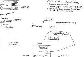
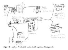
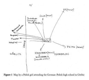
We discussed the article “Visualizing Sovereignty: Cartographic Queries for the Digital Age” and how they in many ways did not succeed in creating an alternative map. That has since reminded me of specific ethnographic methods that I have worked with earlier. It is a method that works with informants creating their own alternative maps of a specific part of their everyday life, and I have come across it in regard to nation borders. It is also called methodological cartography, and the idea is that when you map out something, you also obtain knowledge of something. I have worked with it in the context of the border between Germany and Denmark which is an “open border” meaning no control of crossing. I got inspired by ethnologist Marie Sandbjerg who has done a larger study of the border between Poland and Germany where she asked high school students about their everyday experience with their border. She used mapping as a method and got the students to draw their everyday lives around borders. Some of her findings were about how the border had different meanings and were interacted with differently. It is a way of understanding the border in a performative gaze that helps the concept of explaining the formation of realities (such as objects, materials, artifacts and subjects), which is something that happens within practice in people’s lives (Sandbjerg, M. (2009) p. 114). Therefore the border can be enacted in different ways. I think it opens up to an interesting way of understanding maps, borders and sovereignty. I have included some of the drawings from her studies.
The specific method became relevant to me again talking about the way to visualize and theorize Caribbean sovereignty. In the reading by Yarimar Bonilla and Max Hantel they describe how a traditional understanding of sovereignty is different to the history and present of the Caribbean. They describe it as “This history of fractured, uneven, contested, and negotiated sovereignty continues to shape the region as a whole, and at present the majority of societies in the Caribbean are not independent nation-states but rather protectorates, territories, departments, and commonwealths personal”. By using the gaze of borders as performative it opens up to an understanding of the borders not as only drawings on a map but something people enact and interact with. A way to describe and visualize this understanding could be to use methodological cartography. It could be interesting to see if there exists studies of people in the Carribieans own experience of the borders and sovereignty in their everyday lives.
I just wanted to add a last note about even though the borders can be viewed as performative and fluid I still believe they have a big impact on many people’s lives and are meet more as frontier and boundary.
Sandberg, Marie (2009): “Performing the Border: Cartographic Enactments of the German–Polish Border among German and Polish High-school Pupils”, Anthropological Journal of European Cultures Volume 18, 2009: 107–128,

This entry is licensed under a Creative Commons Attribution-NonCommercial-ShareAlike 4.0 International license.